Geolocate

Tigris River topographic map

Click on the map to display elevation.

About this map

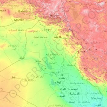
Name: Tigris River topographic map, elevation, terrain.

Location: Tigris River, Iraqi Kurdistan, 10016, Iraq (31.00471 39.53870 38.47892 47.45340)

Average elevation: 760 m

Minimum elevation: 1 m

Maximum elevation: 4,265 m

Other topographic maps

Click on a map to view its topography, its elevation and its terrain.

Qob

Iraq > Iraqi Kurdistan > Qob

Average elevation: 492 m

Karayzi Said

Iraq > Iraqi Kurdistan > Karayzi Said

Average elevation: 803 m

Gear up for your next adventure:

🔦LED Headtorch - Bright and durable light for night activities
🚲Heavy Duty Bike Lock - Secure your bike at the trailhead or during stops
🧦Outdoor Socks - Durable socks designed for hiking and outdoor sports
🥤Collapsible Travel Cup - Saves space and weight in your mess kit
🧥Ultralight Puffy Jacket - Maximum warmth that packs down to the size of an orange

As an Amazon Associate, this site earns from qualifying purchases at no extra cost to you.