
Waterford City Metropolitan District topographic map
Interactive map
Click on the map to display elevation.
About this map
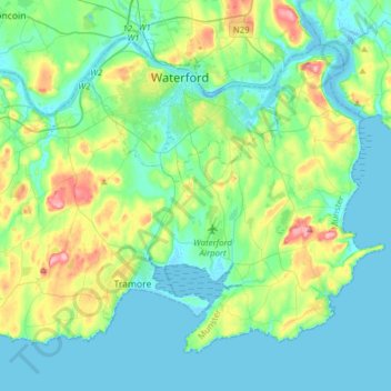
Name: Waterford City Metropolitan District topographic map, elevation, terrain.
Average elevation: 29 m
Minimum elevation: -5 m
Maximum elevation: 128 m
Other topographic maps
Click on a map to view its topography, its elevation and its terrain.
Ballyduff
Ballyduff, The Municipal District of Dungarvan — Lismore, Comté de Waterford, Munster, Irlande
Average elevation: 187 m
The Municipal District of Dungarvan — Lismore
The Municipal District of Dungarvan — Lismore, Comté de Waterford, Munster, Irlande
Average elevation: 120 m
Native Woodland Trust:Grace Dieu Reserve
Native Woodland Trust:Grace Dieu Reserve, Gracedieu, Waterford City Metropolitan District, Comté de Waterford, Munster, Irlande
Average elevation: 27 m
Waterford
Waterford, Comté de Waterford, Munster, Irlande
Average elevation: 33 m
Dungarvan
Dungarvan, The Municipal District of Dungarvan — Lismore, Comté de Waterford, Munster, X35 V670, Irlande
Average elevation: 30 m