Geolocate

Ses Cadenes topographic map

Click on the map to display elevation.

About this map
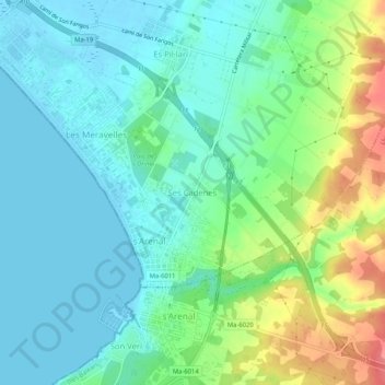
Name: Ses Cadenes topographic map, elevation, terrain.

Location: Ses Cadenes, Palma de Mallorca, Palma, Balearic Islands, 07600, Spain (39.49368 2.73809 39.53368 2.77809)

Average elevation: 22 m

Minimum elevation: -1 m

Maximum elevation: 76 m

Other topographic maps

Click on a map to view its topography, its elevation and its terrain.

Gear up for your next adventure:

🧭GPS Tracker - Track your location in remote areas safely
💡LED Camping Lantern - Illuminate your campsite with long-lasting lanterns
👟Trail Running Shoes - Agile footwear for fast-paced topographic exploration
🥾Light Hiking Boots - Lightweight and comfortable boots for day hikes
🕶️Polarized Sunglasses - Protect your eyes with durable polarized lenses

As an Amazon Associate, this site earns from qualifying purchases at no extra cost to you.