Geolocate

Serraduy topographic map

Click on the map to display elevation.

About this map

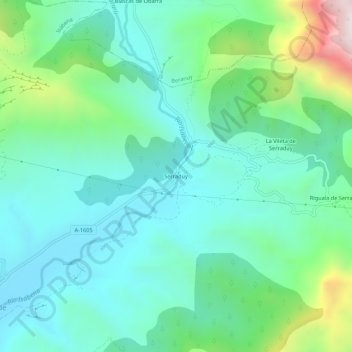
Name: Serraduy topographic map, elevation, terrain.

Location: Serraduy, Isábena, Ribagorza, Huesca, Aragon, 22482, Spain (42.29898 0.55251 42.33898 0.59251)

Average elevation: 949 m

Minimum elevation: 725 m

Maximum elevation: 1,681 m

Other topographic maps

Click on a map to view its topography, its elevation and its terrain.

Capella

Spain > Aragon > Ribagorza

Average elevation: 706 m

Isábena

Spain > Aragon > Ribagorza

Average elevation: 1,026 m

Capella

Spain > Aragon > Ribagorza

Average elevation: 706 m

Gear up for your next adventure:

🪑Ultralight Camping Stool - Compact seating for rest stops during long hikes
💧Hydration Pack - Hands-free hydration system for long hikes
🧢Outdoor Cap - Protective cap for sun and rain during hikes
🥾Waterproof Trail Shoes - Shoes designed to handle wet terrain
💧Collapsible Water Bottle - Space-saving water bottle for outdoor activities

As an Amazon Associate, this site earns from qualifying purchases at no extra cost to you.