Geolocate

Peru topographic map

Click on the map to display elevation.

About this map
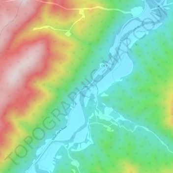
Name: Peru topographic map, elevation, terrain.

Location: Peru, Hardy County, West Virginia, 26838, United States (38.82112 -79.09416 38.86112 -79.05416)

Average elevation: 527 m

Minimum elevation: 328 m

Maximum elevation: 879 m

Other topographic maps

Click on a map to view its topography, its elevation and its terrain.

Lost River

United States > West Virginia > Hardy County > Mathias

Average elevation: 503 m

Moorefield

United States > West Virginia > Hardy County

Average elevation: 261 m

Trout Pond

United States > West Virginia > Hardy County

Average elevation: 657 m

Lost River

United States > West Virginia > Hardy County > Mathias

Average elevation: 504 m

Gear up for your next adventure:

🥾Waterproof Hiking Boots - Essential footwear for rugged terrain and wet Canadian trails
🧤Thermal Hiking Gloves - Grip-enhanced gloves for cold-weather altitude trekking
🧴Outdoor Sunscreen - High SPF protection for high-altitude UV exposure
🥾All-Terrain Hiking Boots - Versatile boots for varied hiking conditions
🧤Rechargeable Heated Gloves - Extreme warmth for Canadian winter expeditions

As an Amazon Associate, this site earns from qualifying purchases at no extra cost to you.