Geolocate

Simga topographic map

Click on the map to display elevation.

About this map

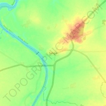
Name: Simga topographic map, elevation, terrain.

Location: Simga, Simga Tahsil, Baloda Bazar, Chhattisgarh, India (21.58757 81.66313 21.66757 81.74313)

Average elevation: 263 m

Minimum elevation: 243 m

Maximum elevation: 283 m

Gear up for your next adventure:

🧼Travel Hand Sanitizer - Keep hands clean when water is scarce
🛏️Camping Sleeping Mat - Comfortable mats for sleeping outdoors
👖Convertible Hiking Pants - Zip-off legs to adapt to changing weather conditions
💡LED Camping Lantern - Illuminate your campsite with long-lasting lanterns
🔋Lithium AA Batteries - Long-lasting power that performs in extreme cold

As an Amazon Associate, this site earns from qualifying purchases at no extra cost to you.