Geolocate

Green Level topographic map

Click on the map to display elevation.

About this map

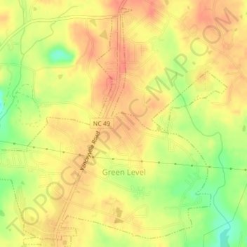
Name: Green Level topographic map, elevation, terrain.

Location: Green Level, Alamance County, North Carolina, United States (36.11324 -79.36441 36.13959 -79.32966)

Average elevation: 189 m

Minimum elevation: 157 m

Maximum elevation: 205 m

Other topographic maps

Click on a map to view its topography, its elevation and its terrain.

Glencoe

United States > North Carolina > Alamance County

Average elevation: 184 m

Elon

United States > North Carolina > Alamance County > Elon

Average elevation: 201 m

Gear up for your next adventure:

🧰Survival Kit - Essential gear for emergencies in the wilderness
🌡️Emergency Mylar Blankets - Compact thermal protection for unexpected nights outdoors
🧶550 Survival Paracord - Versatile utility cord for emergency repairs and rigging
🛰️Satellite Messenger - Emergency communication for areas with no cell service
🧴Sunscreen SPF - Broad-spectrum sunscreen for outdoor activities

As an Amazon Associate, this site earns from qualifying purchases at no extra cost to you.