Geolocate

Loveland topographic map

Click on the map to display elevation.

About this map

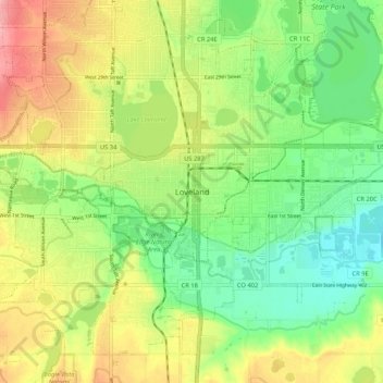
Name: Loveland topographic map, elevation, terrain.

Location: Loveland, Larimer County, Colorado, 80537, United States (40.35776 -105.11498 40.43776 -105.03498)

Average elevation: 1,525 m

Minimum elevation: 1,481 m

Maximum elevation: 1,583 m

Gear up for your next adventure:

🧭GPS Outdoor Watch - Smart watch for navigation and fitness tracking in nature
🔦LED Flashlight - Powerful and long-lasting flashlight for camping and emergencies
🧢Hiking Hat - Sun-protective and breathable hats for long treks
🥾Trekking Boots - Durable boots for long-distance trekking
🔥Emergency Fire Starter - Reliable ignition source for all weather conditions

As an Amazon Associate, this site earns from qualifying purchases at no extra cost to you.