Geolocate

Bedford topographic map

Click on the map to display elevation.

About this map

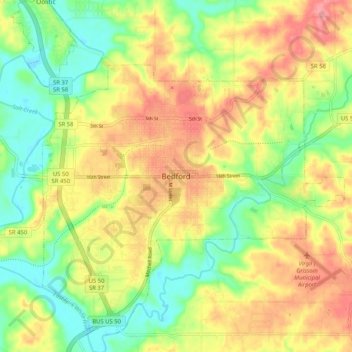
Name: Bedford topographic map, elevation, terrain.

Location: Bedford, Lawrence County, Indiana, 47421, United States (38.82116 -86.52721 38.90116 -86.44721)

Average elevation: 189 m

Minimum elevation: 144 m

Maximum elevation: 238 m

Gear up for your next adventure:

👟Sport Hiking Sandals - Breathable footwear for water crossings and camp rest
🧥Waterproof Hiking Jacket - Protect yourself from rain and wind while hiking
🥾Waterproof Hiking Shoes - Durable shoes for wet and rugged trails
🔋Lithium AA Batteries - Long-lasting power that performs in extreme cold
🚲Handlebar Phone Mount - View topographic-map.com live while cycling

As an Amazon Associate, this site earns from qualifying purchases at no extra cost to you.