
Mollens (VS) topographic map
Click on the map to display elevation.
Mollens (VS)
The former municipality is located in the Sierre district, on the right bank of the Rhone river. The municipality stretches from an elevation of 900 to 3,177 m (2,953 to 10,423 ft). It consists of the villages of Mollens and Cordona, the scattered settlements of Conzor, Laques and Saint-Maurice-de-Laques as well as the resort village of Aminona.
About this map
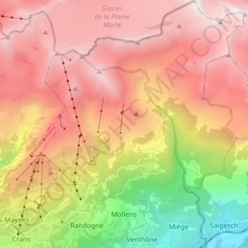
Name: Mollens (VS) topographic map, elevation, terrain.
Location: Mollens (VS), Crans-Montana, Sierre, Wallis, 3960, Switzerland (46.30380 7.49932 46.38897 7.58017)
Average elevation: 1,996 m
Minimum elevation: 543 m
Maximum elevation: 3,150 m
Other topographic maps
Click on a map to view its topography, its elevation and its terrain.
Les Briesses
Switzerland > Wallis > Sierre > Crans-Montana > Chermignon-d'en-Bas
Average elevation: 1,179 m