Geolocate

Brezik topographic map

Click on the map to display elevation.

About this map

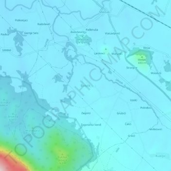
Name: Brezik topographic map, elevation, terrain.

Location: Brezik, Grad Gospić, Lika-Senj County, 53205, Croatia (44.41797 15.48167 44.45797 15.52167)

Average elevation: 592 m

Minimum elevation: 561 m

Maximum elevation: 1,017 m

Other topographic maps

Click on a map to view its topography, its elevation and its terrain.

Kukljić

Croatia > Lika-Senj County > Grad Gospić

Average elevation: 962 m

Gear up for your next adventure:

🥾Mountain Trail Shoes - High-traction shoes for mountain trails
🥫Freeze-Dried Meals - Lightweight, high-calorie nutrition for multi-day treks
🥤Collapsible Travel Cup - Saves space and weight in your mess kit
🏕️Camping Hammock - Integrated protection for sleeping between trees
🧦Thermal Socks - Warm socks for winter hiking or camping

As an Amazon Associate, this site earns from qualifying purchases at no extra cost to you.