Geolocate

Pinayungan topographic map

Click on the map to display elevation.

About this map

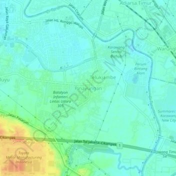
Name: Pinayungan topographic map, elevation, terrain.

Location: Pinayungan, Karawang, West Java, Java, 41313, Indonesia (-6.35892 107.29068 -6.31892 107.33068)

Average elevation: 21 m

Minimum elevation: 11 m

Maximum elevation: 48 m

Other topographic maps

Click on a map to view its topography, its elevation and its terrain.

Sungai Citarum

Indonesia > West Java > Karawang > Sarijaya

Average elevation: 10 m

Tanjungpura

Indonesia > West Java > Karawang

Average elevation: 13 m

Nagasari

Indonesia > West Java > Karawang

Average elevation: 12 m

Purwadana

Indonesia > West Java > Karawang

Average elevation: 14 m

Gear up for your next adventure:

🥾Approach Boots - Comfortable boots for hiking and climbing approaches
🥾Waterproof Trail Shoes - Shoes designed to handle wet terrain
🧢Hiking Hat - Sun-protective and breathable hats for long treks
🧴Bear Spray Holster - Quick-access carry for essential Canadian wilderness safety
🪑Ultralight Camping Stool - Compact seating for rest stops during long hikes

As an Amazon Associate, this site earns from qualifying purchases at no extra cost to you.