Geolocate

Ibach topographic map

Click on the map to display elevation.

About this map

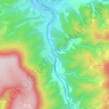
Name: Ibach topographic map, elevation, terrain.

Location: Ibach, Oppenau, Verwaltungsverband Oberes Renchtal, Ortenaukreis, Baden-Württemberg, 77728, Deutschland (48.43495 8.14345 48.47495 8.18345)

Average elevation: 476 m

Minimum elevation: 262 m

Maximum elevation: 785 m

Other topographic maps

Click on a map to view its topography, its elevation and its terrain.

77728

Deutschland > Baden-Württemberg > Ortenaukreis > Oppenau

Average elevation: 603 m

Gear up for your next adventure:

🧦Thermal Socks - Warm socks for winter hiking or camping
🔦LED Flashlight - Powerful and long-lasting flashlight for camping and emergencies
🦯Trekking Poles - Reduced impact on joints for steep topographic climbs
🥾Waterproof Hiking Boots - Essential footwear for rugged terrain and wet Canadian trails
🛏️Camping Sleeping Mat - Comfortable mats for sleeping outdoors

As an Amazon Associate, this site earns from qualifying purchases at no extra cost to you.