Geolocate

Turnerville topographic map

Click on the map to display elevation.

About this map

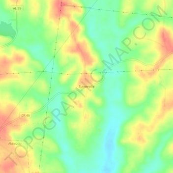
Name: Turnerville topographic map, elevation, terrain.

Location: Turnerville, Henry County, Alabama, 36310, United States (31.58514 -85.22944 31.62514 -85.18944)

Average elevation: 111 m

Minimum elevation: 78 m

Maximum elevation: 149 m

Other topographic maps

Click on a map to view its topography, its elevation and its terrain.

Haleburg

United States > Alabama > Henry County

Average elevation: 93 m

Abbeville

United States > Alabama > Henry County

Average elevation: 118 m

Headland

United States > Alabama > Henry County

Average elevation: 102 m

Gear up for your next adventure:

🧴Bear Spray Holster - Quick-access carry for essential Canadian wilderness safety
🪜Heavy Duty Carabiners - Multi-use clips for securing gear to your backpack
🥾Approach Shoes - Shoes designed for climbing approaches and rugged trails
🕯️Camping Lantern - Illuminates your entire campsite with high-efficiency LEDs
🥤Collapsible Travel Cup - Saves space and weight in your mess kit

As an Amazon Associate, this site earns from qualifying purchases at no extra cost to you.