Geolocate

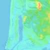
Port de Capbreton topographic map

Click on the map to display elevation.

About this map

Name: Port de Capbreton topographic map, elevation, terrain.

Location: Port de Capbreton, Soorts-Hossegor, Arrondissement de Dax, Landes, Nouvelle-Aquitaine, France métropolitaine, 40130, France (43.64771 -1.44008 43.65487 -1.43020)

Average elevation: 5 m

Minimum elevation: -3 m

Maximum elevation: 25 m

Other topographic maps

Click on a map to view its topography, its elevation and its terrain.
Gear up for your next adventure:

🥾Hiking Leggings - Comfortable leggings for outdoor activities
🐕Hiking Dog Pack - Let your canine companion carry their own water and food
🔨Vehicle Emergency Tool - Safety tool for remote road trips to trailheads
🌡️Emergency Mylar Blankets - Compact thermal protection for unexpected nights outdoors
🔥Camping Stove - Portable stoves to cook outdoors with ease

As an Amazon Associate, this site earns from qualifying purchases at no extra cost to you.