Geolocate

Hafford topographic map

Click on the map to display elevation.

About this map

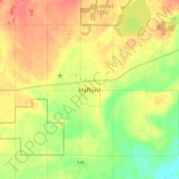
Name: Hafford topographic map, elevation, terrain.

Location: Hafford, Redberry No. 406, Saskatchewan, Canada (52.68563 -107.39191 52.76563 -107.31191)

Average elevation: 588 m

Minimum elevation: 557 m

Maximum elevation: 617 m

Redberry No. 406 trails, hiking, mountain biking, running and outdoor activities

Gear up for your next adventure:

🌡️Emergency Mylar Blankets - Compact thermal protection for unexpected nights outdoors
🧦Thermal Socks - Warm socks for winter hiking or camping
🥫Freeze-Dried Meals - Lightweight, high-calorie nutrition for multi-day treks
🦶Hiking Shoe Insoles - Added support for high arches and long days on feet
🧦Merino Wool Socks - Moisture-wicking comfort for long-distance hiking

As an Amazon Associate, this site earns from qualifying purchases at no extra cost to you.