Geolocate

Lantian topographic map

Click on the map to display elevation.

About this map

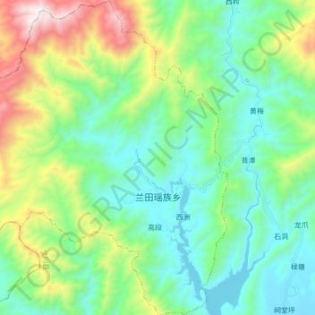
Name: Lantian topographic map, elevation, terrain.

Location: Lantian, Lingchuan County, Guilin, Guangxi, China (25.55748 110.08853 25.69543 110.23060)

Average elevation: 596 m

Minimum elevation: 199 m

Maximum elevation: 1,701 m

Gear up for your next adventure:

🌡️Emergency Mylar Blankets - Compact thermal protection for unexpected nights outdoors
🥾Light Hiking Boots - Lightweight and comfortable boots for day hikes
🦶Anti-Blister Balm - Prevents friction and hotspots during long ascents
🍽️Titanium Camping Spork - Ultralight and indestructible eating utensil
🧤Thermal Hiking Gloves - Grip-enhanced gloves for cold-weather altitude trekking

As an Amazon Associate, this site earns from qualifying purchases at no extra cost to you.