
Kanpur topographic map
Click on the map to display elevation.
Kanpur
Situated in the flat Indo-Gangetic Plains, Kanpur has an average elevation of 318 metres (1,043 ft) above sea level. The Ganga flows by the city and several ghats are located on its banks, notably the Sati Chaura Ghat and Sarsaiya Ghat. The Brahmavart Ghat located at Bithoor (25 km northwards) is another ghat of religious importance.
About this map
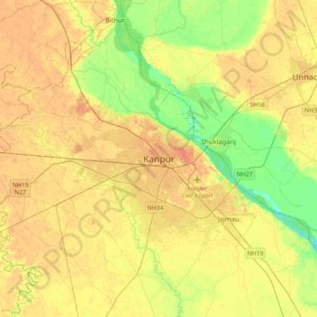
Name: Kanpur topographic map, elevation, terrain.
Location: Kanpur, Kanpur Nagar, Uttar Pradesh, 208012, India (26.30091 80.16176 26.62091 80.48176)
Average elevation: 124 m
Minimum elevation: 105 m
Maximum elevation: 137 m