Geolocate

Vialas topographic map

Click on the map to display elevation.

About this map
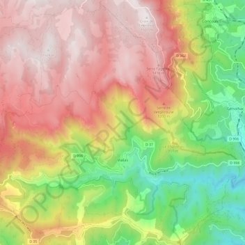
Name: Vialas topographic map, elevation, terrain.

Location: Vialas, Florac, Lozère, Occitania, Metropolitan France, 48220, France (44.30533 3.83421 44.38744 3.95197)

Average elevation: 953 m

Minimum elevation: 333 m

Maximum elevation: 1,502 m

Other topographic maps

Click on a map to view its topography, its elevation and its terrain.
Sauveplane

France > Occitania > Lozère

Average elevation: 463 m

Les Vanels

France > Occitania > Lozère > Vebron

Average elevation: 813 m

Le Coustat

France > Occitania > Lozère > Nasbinals

Average elevation: 1,202 m

Lespartis

France > Occitania > Lozère > Peyre en Aubrac > Aumont-Aubrac

Average elevation: 1,047 m

Gear up for your next adventure:

🧼Travel Hand Sanitizer - Keep hands clean when water is scarce
🥾Trail Running Boots - Durable shoes designed for trail running
🛰️Satellite Messenger - Emergency communication for areas with no cell service
🥫Freeze-Dried Meals - Lightweight, high-calorie nutrition for multi-day treks
⛺Lightweight Camping Tent - Portable shelter optimized for Canadian backcountry camping

As an Amazon Associate, this site earns from qualifying purchases at no extra cost to you.