
Make a donation
Gear up for your next adventure:
As an Amazon Associate, this site earns from qualifying purchases at no extra cost to you.
Pine topographic map
Click on the map to display elevation.
Make a donation
Gear up for your next adventure:
As an Amazon Associate, this site earns from qualifying purchases at no extra cost to you.
About this map
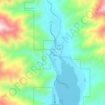
Name: Pine topographic map, elevation, terrain.
Location: Pine, Elmore County, Idaho, United States (43.46519 -115.33123 43.50519 -115.29123)
Average elevation: 1,462 m
Minimum elevation: 1,269 m
Maximum elevation: 1,905 m
Make a donation
Gear up for your next adventure:
As an Amazon Associate, this site earns from qualifying purchases at no extra cost to you.
Other topographic maps
Click on a map to view its topography, its elevation and its terrain.
Glenns Ferry
United States > Idaho > Elmore County
Glenns Ferry is located at 42°57′7″N 115°18′4″W / 42.95194°N 115.30111°W / 42.95194; -115.30111 (42.951954, -115.301132), at an elevation of 2,569 feet (783 m) above sea level.
Average elevation: 798 m