
Thank you for supporting this site ❤️
Make a donation
Make a donation
Gear up for your next adventure:
As an Amazon Associate, this site earns from qualifying purchases at no extra cost to you.
Estremoz topographic map
Click on the map to display elevation.
Thank you for supporting this site ❤️
Make a donation
Make a donation
Gear up for your next adventure:
As an Amazon Associate, this site earns from qualifying purchases at no extra cost to you.
About this map
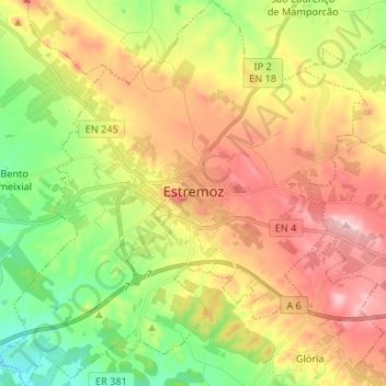
Name: Estremoz topographic map, elevation, terrain.
Location: Estremoz, Évora, Alentejo Central, Alentejo, Portugal (38.79105 -7.65357 38.89425 -7.52748)
Average elevation: 365 m
Minimum elevation: 231 m
Maximum elevation: 517 m
Thank you for supporting this site ❤️
Make a donation
Make a donation
Gear up for your next adventure:
As an Amazon Associate, this site earns from qualifying purchases at no extra cost to you.