Geolocate

Amas topographic map

Click on the map to display elevation.

About this map

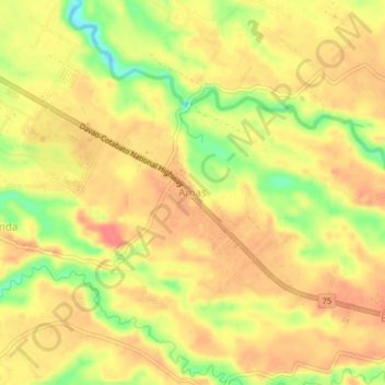
Name: Amas topographic map, elevation, terrain.

Location: Amas, Kidapawan, Cotabato, Soccsksargen, 9400, Philippines (7.03618 124.96492 7.07618 125.00492)

Average elevation: 96 m

Minimum elevation: 55 m

Maximum elevation: 118 m

Other topographic maps

Click on a map to view its topography, its elevation and its terrain.

Pulangi River

Philippines > Cotabato > Kidapawan

Average elevation: 440 m

Matingao River

Philippines > Cotabato > Kidapawan > Balabag

Average elevation: 605 m

Gear up for your next adventure:

🔭Outdoor Binoculars - Lightweight binoculars for birdwatching and hiking
🧴Sunscreen SPF - Broad-spectrum sunscreen for outdoor activities
Family Camping Tent - Spacious tent suitable for family camping trips
🥾Trekking Boots - Durable boots for long-distance trekking
🥾Waterproof Hiking Boots - Essential footwear for rugged terrain and wet Canadian trails

As an Amazon Associate, this site earns from qualifying purchases at no extra cost to you.