Geolocate

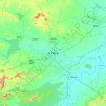
Nashik topographic map

Click on the map to display elevation.

Nashik

The city's tropical location and high altitude combine to give it a relatively mild version of a tropical wet and dry climate (Köppen Aw). Temperatures rise slightly in October, but this is followed by the cool season from November to February. The cool season sees warm temperatures of around 28 °C or 82.4 °F during the day, but cool nights, with lows averaging 10 °C or 50 °F, and extremely dry air.

Wikipedia (CC-BY-SA 3.0)

About this map

Name: Nashik topographic map, elevation, terrain.

Location: Nashik, Nashik Subdistrict, Nashik District, Maharashtra, 422001, India (19.85125 73.63024 20.17125 73.95024)

Average elevation: 631 m

Minimum elevation: 535 m

Maximum elevation: 1,079 m

Gear up for your next adventure:

🚑Survival Whistle - Signal for help across long distances in mountains
🧥Packable Rain Jacket - Breathable waterproof layer for unpredictable weather
🥾Waterproof Hiking Boots - Boots keeping your feet dry in wet conditions
👖Convertible Hiking Pants - Zip-off legs to adapt to changing weather conditions
🧦Thermal Socks - Warm socks for winter hiking or camping

As an Amazon Associate, this site earns from qualifying purchases at no extra cost to you.