
Thank you for supporting this site ❤️
Make a donation
Make a donation
Gear up for your next adventure:
As an Amazon Associate, this site earns from qualifying purchases at no extra cost to you.
Villarrica topographic map
Click on the map to display elevation.
Thank you for supporting this site ❤️
Make a donation
Make a donation
Gear up for your next adventure:
As an Amazon Associate, this site earns from qualifying purchases at no extra cost to you.
About this map
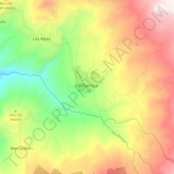
Name: Villarrica topographic map, elevation, terrain.
Location: Villarrica, Oriente, Tolima, RAP Eje Cafetero, Colombia (3.89548 -74.64027 3.97548 -74.56027)
Average elevation: 1,306 m
Minimum elevation: 710 m
Maximum elevation: 1,946 m
Thank you for supporting this site ❤️
Make a donation
Make a donation
Gear up for your next adventure:
As an Amazon Associate, this site earns from qualifying purchases at no extra cost to you.