
Make a donation
Gear up for your next adventure:
As an Amazon Associate, this site earns from qualifying purchases at no extra cost to you.
Monte Pellegrino topographic map
Click on the map to display elevation.
Make a donation
Gear up for your next adventure:
As an Amazon Associate, this site earns from qualifying purchases at no extra cost to you.
Monte Pellegrino
Der Monte Pellegrino („Pilgerberg'“) ist ein Berg an der Nordküste Siziliens. Er liegt etwa vier Kilometer nördlich des Stadtzentrums von Palermo. Die maximale Höhe des Kalkberges beträgt 606 Meter.
Make a donation
Gear up for your next adventure:
As an Amazon Associate, this site earns from qualifying purchases at no extra cost to you.
About this map
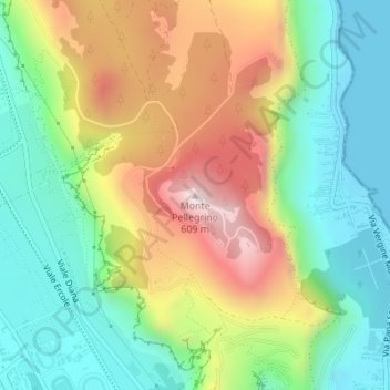
Name: Monte Pellegrino topographic map, elevation, terrain.
Location: Monte Pellegrino, Palermo, Sizilien, 90167, Italien (38.16606 13.35375 38.16616 13.35385)
Average elevation: 230 m
Minimum elevation: 0 m
Maximum elevation: 592 m
Make a donation
Gear up for your next adventure:
As an Amazon Associate, this site earns from qualifying purchases at no extra cost to you.