Geolocate

Costeni topographic map

Click on the map to display elevation.

About this map

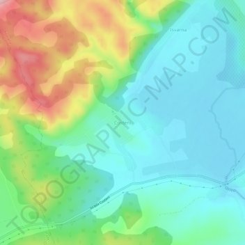
Name: Costeni topographic map, elevation, terrain.

Location: Costeni, Tismana, Gorj, 217497, Romania (44.99756 22.87543 45.03756 22.91543)

Average elevation: 267 m

Minimum elevation: 194 m

Maximum elevation: 444 m

Gear up for your next adventure:

👟Trail Running Shoes - Agile footwear for fast-paced topographic exploration
🔭Outdoor Binoculars - Lightweight binoculars for birdwatching and hiking
🛏️Sleeping Bag - Warm and compact sleeping bags for outdoor camping
🏕️Camping Hammock - Integrated protection for sleeping between trees
🧢Sun Protection Cap - Breathable cap to protect from sun exposure

As an Amazon Associate, this site earns from qualifying purchases at no extra cost to you.