
Thank you for supporting this site ❤️
Make a donation
Make a donation
Gear up for your next adventure:
As an Amazon Associate, this site earns from qualifying purchases at no extra cost to you.
Tupiza topographic map
Click on the map to display elevation.
Thank you for supporting this site ❤️
Make a donation
Make a donation
Gear up for your next adventure:
As an Amazon Associate, this site earns from qualifying purchases at no extra cost to you.
Tupiza
Se localiza en las coordenadas 21°26′15″S 65°42′57″O / -21.43750, -65.71583, a una altitud de 2.850 msnm.
Thank you for supporting this site ❤️
Make a donation
Make a donation
Gear up for your next adventure:
As an Amazon Associate, this site earns from qualifying purchases at no extra cost to you.
About this map
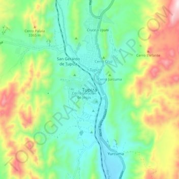
Name: Tupiza topographic map, elevation, terrain.
Location: Tupiza, Provincia Sur Chichas, Potosí, 512, Bolivia (-21.48377 -65.76084 -21.40377 -65.68084)
Average elevation: 3,164 m
Minimum elevation: 2,909 m
Maximum elevation: 3,681 m
Thank you for supporting this site ❤️
Make a donation
Make a donation
Gear up for your next adventure:
As an Amazon Associate, this site earns from qualifying purchases at no extra cost to you.