
Make a donation
Gear up for your next adventure:
As an Amazon Associate, this site earns from qualifying purchases at no extra cost to you.
Jongieux topographic map
Click on the map to display elevation.
Make a donation
Gear up for your next adventure:
As an Amazon Associate, this site earns from qualifying purchases at no extra cost to you.
About this map
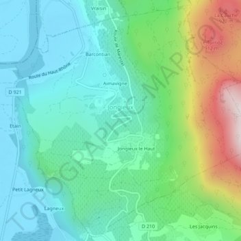
Name: Jongieux topographic map, elevation, terrain.
Average elevation: 442 m
Minimum elevation: 223 m
Maximum elevation: 1,051 m
Make a donation
Gear up for your next adventure:
As an Amazon Associate, this site earns from qualifying purchases at no extra cost to you.
Other topographic maps
Click on a map to view its topography, its elevation and its terrain.
Éboulement de Vérel
France > Auvergne-Rhône-Alpes > Savoy > Verel-Pragondran > Vérel > Les Chavannes
Average elevation: 753 m
Pointe du Villonet
France > Auvergne-Rhône-Alpes > Savoy > Saint-Colomban-des-Villards
Average elevation: 2,256 m
Rocher du Marais ou le Grand Rond
France > Auvergne-Rhône-Alpes > Savoy > Tignes
Average elevation: 2,280 m
Make a donation
Gear up for your next adventure:
As an Amazon Associate, this site earns from qualifying purchases at no extra cost to you.