
Thank you for supporting this site ❤️
Make a donation
Make a donation
Gear up for your next adventure:
As an Amazon Associate, this site earns from qualifying purchases at no extra cost to you.
Soria topographic map
Click on the map to display elevation.
Thank you for supporting this site ❤️
Make a donation
Make a donation
Gear up for your next adventure:
As an Amazon Associate, this site earns from qualifying purchases at no extra cost to you.
About this map
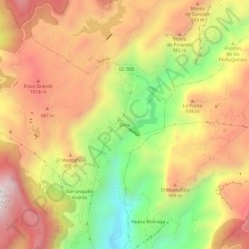
Name: Soria topographic map, elevation, terrain.
Location: Soria, Mogán, Las Palmas, Îles Canaries, Espagne (27.88645 -15.68871 27.92645 -15.64871)
Average elevation: 792 m
Minimum elevation: 275 m
Maximum elevation: 1,215 m
Thank you for supporting this site ❤️
Make a donation
Make a donation
Gear up for your next adventure:
As an Amazon Associate, this site earns from qualifying purchases at no extra cost to you.