
Make a donation
Gear up for your next adventure:
As an Amazon Associate, this site earns from qualifying purchases at no extra cost to you.
Gemeinde Dürnstein topographic map
Click on the map to display elevation.
Make a donation
Gear up for your next adventure:
As an Amazon Associate, this site earns from qualifying purchases at no extra cost to you.
About this map
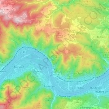
Name: Gemeinde Dürnstein topographic map, elevation, terrain.
Location: Gemeinde Dürnstein, Bezirk Krems, Lower Austria, 3601, Austria (48.38399 15.46369 48.43085 15.56227)
Average elevation: 382 m
Minimum elevation: 187 m
Maximum elevation: 706 m
Make a donation
Gear up for your next adventure:
As an Amazon Associate, this site earns from qualifying purchases at no extra cost to you.
Other topographic maps
Click on a map to view its topography, its elevation and its terrain.
Make a donation
Gear up for your next adventure:
As an Amazon Associate, this site earns from qualifying purchases at no extra cost to you.
Loiwein
Austria > Lower Austria > Bezirk Krems > Gemeinde Lichtenau im Waldviertel
Average elevation: 552 m