
Thank you for supporting this site ❤️
Make a donation
Make a donation
Gear up for your next adventure:
As an Amazon Associate, this site earns from qualifying purchases at no extra cost to you.
Kyungzê topographic map
Click on the map to display elevation.
Thank you for supporting this site ❤️
Make a donation
Make a donation
Gear up for your next adventure:
As an Amazon Associate, this site earns from qualifying purchases at no extra cost to you.
About this map
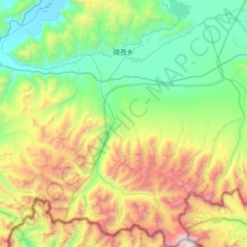
Name: Kyungzê topographic map, elevation, terrain.
Location: Kyungzê, Dinggyê County, Shigatse Prefecture, Tibet, China (27.86736 87.80867 28.30546 88.24966)
Average elevation: 5,144 m
Minimum elevation: 4,201 m
Maximum elevation: 7,452 m
Thank you for supporting this site ❤️
Make a donation
Make a donation
Gear up for your next adventure:
As an Amazon Associate, this site earns from qualifying purchases at no extra cost to you.