
Make a donation
Gear up for your next adventure:
As an Amazon Associate, this site earns from qualifying purchases at no extra cost to you.
São Francisco de Paula topographic map
Click on the map to display elevation.
Make a donation
Gear up for your next adventure:
As an Amazon Associate, this site earns from qualifying purchases at no extra cost to you.
About this map
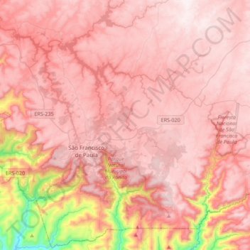
Name: São Francisco de Paula topographic map, elevation, terrain.
Average elevation: 758 m
Minimum elevation: 55 m
Maximum elevation: 1,030 m
Make a donation
Gear up for your next adventure:
As an Amazon Associate, this site earns from qualifying purchases at no extra cost to you.
Other topographic maps
Click on a map to view its topography, its elevation and its terrain.
Campestre do Tigre
Brasil > Rio Grande do Sul > São Francisco de Paula > Campestre do Tigre
Average elevation: 792 m
Make a donation
Gear up for your next adventure:
As an Amazon Associate, this site earns from qualifying purchases at no extra cost to you.
Cachoeiras Gemeas Gigantes
Brasil > Rio Grande do Sul > São Francisco de Paula
Average elevation: 831 m
Fazenda Baú
Brasil > Rio Grande do Sul > São Francisco de Paula > Fazenda Baú
Average elevation: 859 m
Make a donation
Gear up for your next adventure:
As an Amazon Associate, this site earns from qualifying purchases at no extra cost to you.