Geolocate

Tona topographic map

Click on the map to display elevation.

About this map

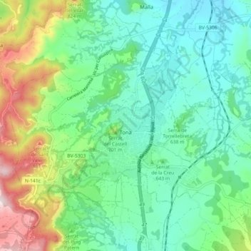
Name: Tona topographic map, elevation, terrain.

Location: Tona, Osona, Barcelona, Catalonia, 08551, Spain (41.83541 2.18621 41.87561 2.27546)

Average elevation: 645 m

Minimum elevation: 508 m

Maximum elevation: 998 m

Other topographic maps

Click on a map to view its topography, its elevation and its terrain.

Pla de la Calma

Spain > Catalonia > Osona > el Brull

Average elevation: 1,111 m

Sora

Spain > Catalonia > Osona > Sora > Sora

Average elevation: 750 m

Gear up for your next adventure:

🎒Hiking Backpack - Lightweight and ergonomic backpacks for day hikes or multi-day treks
🧦Hiking Liner Socks - Thin base layer to prevent friction and blisters
🦟Insect Repellent - Keep mosquitoes and black flies away in wooded areas
🧥Fleece Jacket - Warm and lightweight jacket for layering
🥾Waterproof Hiking Shoes - Durable shoes for wet and rugged trails

As an Amazon Associate, this site earns from qualifying purchases at no extra cost to you.