Geolocate

Tandes topographic map

Click on the map to display elevation.

About this map

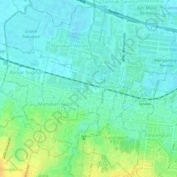
Name: Tandes topographic map, elevation, terrain.

Location: Tandes, Surabaya, East Java, 60185, Indonesia (-7.27687 112.65440 -7.23618 112.69207)

Average elevation: 9 m

Minimum elevation: 0 m

Maximum elevation: 28 m

Other topographic maps

Click on a map to view its topography, its elevation and its terrain.

Asemrowo

Indonesia > East Java > Surabaya

Average elevation: 4 m

Taman Prestasi

Indonesia > East Java > Surabaya > Ketabang

Average elevation: 6 m

Dukuh Pakis

Indonesia > East Java > Surabaya

Average elevation: 9 m

Dukuh Pakis

Indonesia > East Java > Surabaya

Average elevation: 15 m

Gear up for your next adventure:

🛰️Satellite Messenger - Emergency communication for areas with no cell service
🧥Softshell Jacket - Windproof and breathable jacket for hiking
🔨Vehicle Emergency Tool - Safety tool for remote road trips to trailheads
👖Convertible Hiking Pants - Zip-off legs to adapt to changing weather conditions
🥾Mountain Trail Shoes - High-traction shoes for mountain trails

As an Amazon Associate, this site earns from qualifying purchases at no extra cost to you.