Geolocate

Reece topographic map

Click on the map to display elevation.

About this map

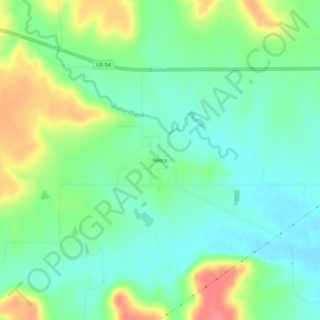
Name: Reece topographic map, elevation, terrain.

Location: Reece, Greenwood County, Kansas, United States (37.77891 -96.46640 37.81891 -96.42640)

Average elevation: 378 m

Minimum elevation: 352 m

Maximum elevation: 428 m

Other topographic maps

Click on a map to view its topography, its elevation and its terrain.

Madison

United States > Kansas > Greenwood County

Average elevation: 347 m

Gear up for your next adventure:

🚑Survival Whistle - Signal for help across long distances in mountains
🥾Hiking Boots - Sturdy boots providing ankle support and traction on rugged trails
🥾Trail Hiking Shoes - Durable shoes designed for rugged trails
🧥Waterproof Jacket - Lightweight rain jackets for hiking and outdoor activities
🧴Outdoor Sunscreen - High SPF protection for high-altitude UV exposure

As an Amazon Associate, this site earns from qualifying purchases at no extra cost to you.