
Make a donation
Gear up for your next adventure:
As an Amazon Associate, this site earns from qualifying purchases at no extra cost to you.
Ernstthal topographic map
Click on the map to display elevation.
Make a donation
Gear up for your next adventure:
As an Amazon Associate, this site earns from qualifying purchases at no extra cost to you.
Ernstthal
Ernstthal liegt im Thüringer Schiefergebirge am Rennsteig zwischen den Städten Sonneberg, Ilmenau und Saalfeld. Es ist ein Ortsteil an der bewaldeten Thüringer Kammlage mit 770 Meter über NN. Er befindet sich an der Südabdachung des Gebirges. Die Landesstraße 1149 und die Kreisstraße 35 erfassen den höhergelegenen Ortsteil mit den in den Tälern liegenden Zentren.
Make a donation
Gear up for your next adventure:
As an Amazon Associate, this site earns from qualifying purchases at no extra cost to you.
About this map
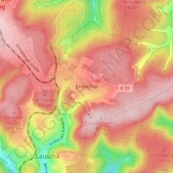
Name: Ernstthal topographic map, elevation, terrain.
Average elevation: 756 m
Minimum elevation: 605 m
Maximum elevation: 834 m
Make a donation
Gear up for your next adventure:
As an Amazon Associate, this site earns from qualifying purchases at no extra cost to you.