Geolocate

Nivin topographic map

Click on the map to display elevation.

About this map

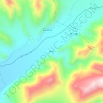
Name: Nivin topographic map, elevation, terrain.

Location: Nivin, Casma, Áncash, Perú (-9.55917 -78.16001 -9.51917 -78.12001)

Average elevation: 411 m

Minimum elevation: 208 m

Maximum elevation: 831 m

Other topographic maps

Click on a map to view its topography, its elevation and its terrain.

Sitio Arqueologico Chankillo

Perú > Áncash > Casma > Carrizal > Nivin

Average elevation: 201 m

Gear up for your next adventure:

🛶Waterproof Dry Bags - Keep electronics and clothes dry during river crossings
💡Compact LED Flashlight - Powerful and portable flashlight for outdoor use
🩹Compact First Aid Kit - Pre-packed essentials for common trail injuries
🧭GPS Handheld Device - Reliable GPS navigation for outdoor adventures
🥾Mountain Trail Shoes - High-traction shoes for mountain trails

As an Amazon Associate, this site earns from qualifying purchases at no extra cost to you.