
Make a donation
Gear up for your next adventure:
As an Amazon Associate, this site earns from qualifying purchases at no extra cost to you.
85440 topographic map
Click on the map to display elevation.
Make a donation
Gear up for your next adventure:
As an Amazon Associate, this site earns from qualifying purchases at no extra cost to you.
About this map
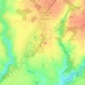
Name: 85440 topographic map, elevation, terrain.
Average elevation: 38 m
Minimum elevation: 11 m
Maximum elevation: 54 m
Make a donation
Gear up for your next adventure:
As an Amazon Associate, this site earns from qualifying purchases at no extra cost to you.
Other topographic maps
Click on a map to view its topography, its elevation and its terrain.
Le Fiei Martel
France > Pays de la Loire > Vendée > Talmont-Saint-Hilaire > Saint-Hilaire-de-Talmont
Average elevation: 17 m
Make a donation
Gear up for your next adventure:
As an Amazon Associate, this site earns from qualifying purchases at no extra cost to you.
Ilaude
France > Pays de la Loire > Vendée > Talmont-Saint-Hilaire > La Guittière
Average elevation: 5 m
La Miltière
France > Pays de la Loire > Vendée > Talmont-Saint-Hilaire > La Guittière
Average elevation: 13 m
Saint-Hilaire-de-Talmont
France > Pays de la Loire > Vendée > Talmont-Saint-Hilaire
Average elevation: 20 m
Make a donation
Gear up for your next adventure:
As an Amazon Associate, this site earns from qualifying purchases at no extra cost to you.
Les Hautes Mers
France > Pays de la Loire > Vendée > Talmont-Saint-Hilaire > Querry Pigeon
Average elevation: 13 m