Geolocate

Guarnizo topographic map

Click on the map to display elevation.

About this map

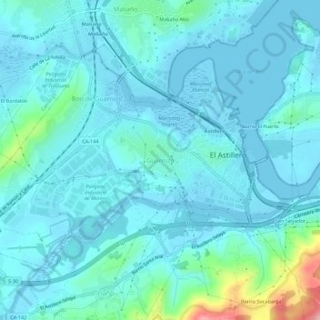
Name: Guarnizo topographic map, elevation, terrain.

Location: Guarnizo, El Astillero, Cantabria, 39611, España (43.37953 -3.85026 43.41953 -3.81026)

Average elevation: 23 m

Minimum elevation: -5 m

Maximum elevation: 176 m

Other topographic maps

Click on a map to view its topography, its elevation and its terrain.

Marismas Negras

España > Cantabria > El Astillero > Guarnizo

Average elevation: 10 m

Gear up for your next adventure:

🧦Hiking Socks - Moisture-wicking and comfortable socks for long hikes
🔪Outdoor Multitool - Versatile tool for repairs and food prep in the wild
🛏️Camping Sleeping Mat - Comfortable mats for sleeping outdoors
🥾Lightweight Hiking Boots - Boots for comfort and mobility on long hikes
🧢Sun Protection Cap - Breathable cap to protect from sun exposure

As an Amazon Associate, this site earns from qualifying purchases at no extra cost to you.