Geolocate

Bari topographic map

Click on the map to display elevation.

About this map

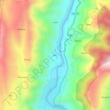
Name: Bari topographic map, elevation, terrain.

Location: Bari, Mandi, Mandi District, Himachal Pradesh, 175001, India (31.71160 76.91292 31.75160 76.95292)

Average elevation: 1,068 m

Minimum elevation: 711 m

Maximum elevation: 1,531 m

Other topographic maps

Click on a map to view its topography, its elevation and its terrain.

Beas River

India > Himachal Pradesh > Mandi > Mandi > Bari

Average elevation: 948 m

Gear up for your next adventure:

💡Compact LED Flashlight - Powerful and portable flashlight for outdoor use
💧Reusable Water Bottle - Durable water bottles for hydration on trails
🧰Emergency Multi-Tool - Compact multi-tool for outdoor survival
🥾Mountain Hiking Boots - High-traction boots for rocky terrain
🎒Fully Waterproof Backpack - Total protection for photography gear and electronics

As an Amazon Associate, this site earns from qualifying purchases at no extra cost to you.