
Védrines le Cerf topographic map
Interactive map
Click on the map to display elevation.
About this map
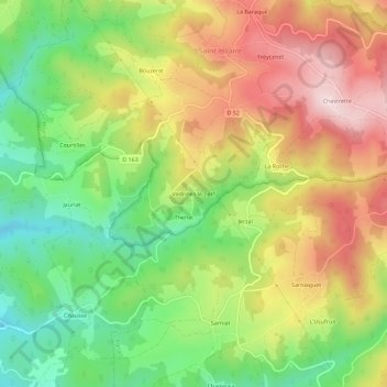
Name: Védrines le Cerf topographic map, elevation, terrain.
Average elevation: 645 m
Minimum elevation: 478 m
Maximum elevation: 831 m
Other topographic maps
Click on a map to view its topography, its elevation and its terrain.
Le Pin
France > Auvergne-Rhône-Alpes > Haute-Loire > Saint-Hilaire
Le Pin, Saint-Hilaire, Brioude, Haute-Loire, Auvergne-Rhône-Alpes, France métropolitaine, 43390, France
Average elevation: 699 m