
Thank you for supporting this site ❤️
Make a donation
Make a donation
Gear up for your next adventure:
As an Amazon Associate, this site earns from qualifying purchases at no extra cost to you.
Höntrup topographic map
Click on the map to display elevation.
Thank you for supporting this site ❤️
Make a donation
Make a donation
Gear up for your next adventure:
As an Amazon Associate, this site earns from qualifying purchases at no extra cost to you.
About this map
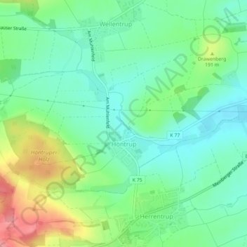
Name: Höntrup topographic map, elevation, terrain.
Location: Höntrup, Blomberg, Kreis Lippe, Nordrhein-Westfalen, Deutschland (51.92226 9.00928 51.93757 9.04438)
Average elevation: 167 m
Minimum elevation: 136 m
Maximum elevation: 231 m
Thank you for supporting this site ❤️
Make a donation
Make a donation
Gear up for your next adventure:
As an Amazon Associate, this site earns from qualifying purchases at no extra cost to you.
Other topographic maps
Click on a map to view its topography, its elevation and its terrain.
Trift
Deutschland > Nordrhein-Westfalen > Kreis Lippe > Blomberg > Eschenbruch
Average elevation: 254 m