Geolocate

Surf City topographic map

Click on the map to display elevation.

About this map

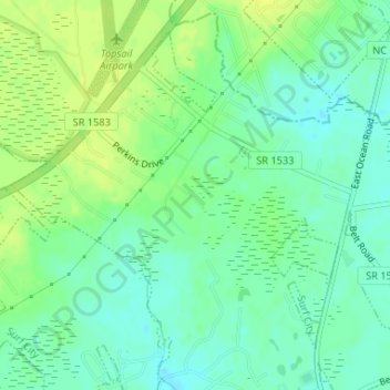
Name: Surf City topographic map, elevation, terrain.

Location: Surf City, Pender County, North Carolina, United States (34.45977 -77.57980 34.46919 -77.56899)

Average elevation: 10 m

Minimum elevation: 1 m

Maximum elevation: 18 m

Other topographic maps

Click on a map to view its topography, its elevation and its terrain.

Topsail

United States > North Carolina > Pender County

Average elevation: 10 m

Gear up for your next adventure:

🥾Trekking Poles - Adjustable trekking poles to reduce knee stress and improve stability
🧢Outdoor Visor - Breathable visor for sunny hikes
🧥Waterproof Hiking Jacket - Protect yourself from rain and wind while hiking
🎒Fully Waterproof Backpack - Total protection for photography gear and electronics
💧Filtered Water Bottle - Safe drinking water on the go

As an Amazon Associate, this site earns from qualifying purchases at no extra cost to you.