
Make a donation
Gear up for your next adventure:
As an Amazon Associate, this site earns from qualifying purchases at no extra cost to you.
Villota de Elines topographic map
Click on the map to display elevation.
Make a donation
Gear up for your next adventure:
As an Amazon Associate, this site earns from qualifying purchases at no extra cost to you.
Villota de Elines
Se encuentra a 819 m s. n. m. Dista diez kilómetros de Polientes, la capital municipal. Desde esta localidad se asciende con facilidad a La Muñata (1181 metros de altitud), pico desde el que se tienen vistas panorámicas sobre el valle.
Make a donation
Gear up for your next adventure:
As an Amazon Associate, this site earns from qualifying purchases at no extra cost to you.
About this map
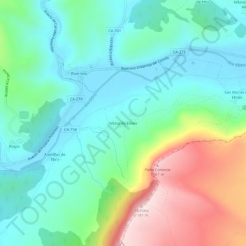
Name: Villota de Elines topographic map, elevation, terrain.
Location: Villota de Elines, Valderredible, Cantabria, 39232, España (42.80391 -3.91415 42.84391 -3.87415)
Average elevation: 827 m
Minimum elevation: 684 m
Maximum elevation: 1,178 m
Make a donation
Gear up for your next adventure:
As an Amazon Associate, this site earns from qualifying purchases at no extra cost to you.
Other topographic maps
Click on a map to view its topography, its elevation and its terrain.