
Thank you for supporting this site ❤️
Make a donation
Make a donation
Gear up for your next adventure:
As an Amazon Associate, this site earns from qualifying purchases at no extra cost to you.
McFarland topographic map
Click on the map to display elevation.
Thank you for supporting this site ❤️
Make a donation
Make a donation
Gear up for your next adventure:
As an Amazon Associate, this site earns from qualifying purchases at no extra cost to you.
About this map
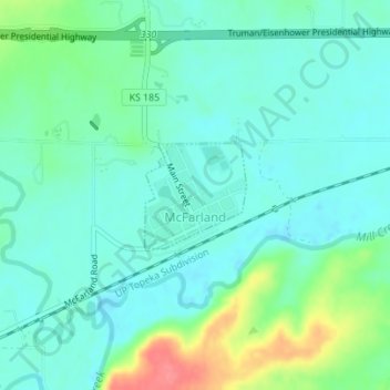
Name: McFarland topographic map, elevation, terrain.
Location: McFarland, Wabaunsee County, Kansas, 66501, United States (39.05056 -96.24229 39.05792 -96.23320)
Average elevation: 320 m
Minimum elevation: 302 m
Maximum elevation: 374 m
Thank you for supporting this site ❤️
Make a donation
Make a donation
Gear up for your next adventure:
As an Amazon Associate, this site earns from qualifying purchases at no extra cost to you.
Other topographic maps
Click on a map to view its topography, its elevation and its terrain.
Mount Mitchell Heritage Prairie Park
United States > Kansas > Wabaunsee County > Wamego
Average elevation: 325 m