
Make a donation
Gear up for your next adventure:
As an Amazon Associate, this site earns from qualifying purchases at no extra cost to you.
Chenowith topographic map
Click on the map to display elevation.
Make a donation
Gear up for your next adventure:
As an Amazon Associate, this site earns from qualifying purchases at no extra cost to you.
About this map
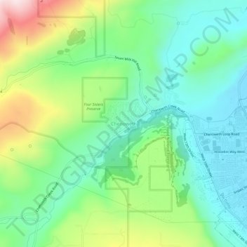
Name: Chenowith topographic map, elevation, terrain.
Location: Chenowith, Wasco County, Oregon, 95058, United States (45.60762 -121.26341 45.64762 -121.22341)
Average elevation: 193 m
Minimum elevation: 39 m
Maximum elevation: 531 m
Make a donation
Gear up for your next adventure:
As an Amazon Associate, this site earns from qualifying purchases at no extra cost to you.
Other topographic maps
Click on a map to view its topography, its elevation and its terrain.
Shaniko
United States > Oregon > Wasco County > Shaniko
The city is at an elevation of 3,343 feet (1,019 m). On the high plateau on which Shaniko was built, the soil is thin and the vegetation sparse, consisting mainly of sagebrush, bunchgrass, and occasional junipers. Many peaks of the Cascade Range, including Hood, Jefferson, Adams, St. Helens and Rainier, are…
Average elevation: 1,009 m
Make a donation
Gear up for your next adventure:
As an Amazon Associate, this site earns from qualifying purchases at no extra cost to you.