Geolocate

St. Tudy topographic map

Click on the map to display elevation.

About this map

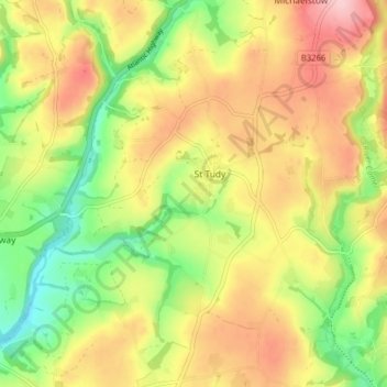
Name: St. Tudy topographic map, elevation, terrain.

Location: St. Tudy, Cornwall, England, United Kingdom (50.52732 -4.76348 50.57778 -4.70222)

Average elevation: 105 m

Minimum elevation: 21 m

Maximum elevation: 189 m

Other topographic maps

Click on a map to view its topography, its elevation and its terrain.

Trembraze

United Kingdom > England > Cornwall > Liskeard

Average elevation: 128 m

Freathy

United Kingdom > England > Cornwall

Average elevation: 37 m

Riviere Towans

United Kingdom > England > Cornwall > Hayle > Phillack

Average elevation: 19 m

Pinnacle Gully

United Kingdom > England > Cornwall > Porthgwarra

Average elevation: 19 m

Gear up for your next adventure:

🥾Hiking Boots - Sturdy boots providing ankle support and traction on rugged trails
🧢Outdoor Cap - Protective cap for sun and rain during hikes
🧊Insulated Water Bottle - Keeps drinks cold in summer and prevents freezing in winter
🥾Trekking Poles - Adjustable trekking poles to reduce knee stress and improve stability
🥾Trekking Boots - Durable boots for long-distance trekking

As an Amazon Associate, this site earns from qualifying purchases at no extra cost to you.