
Socotra topographic map
Interactive map
Click on the map to display elevation.
About this map
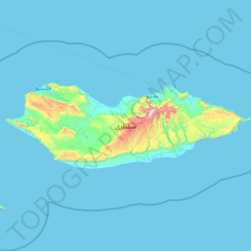
Name: Socotra topographic map, elevation, terrain.
Location: Socotra, Hidaybu District, Socotra Governorate, Yemen (12.30133 53.30537 12.71368 54.53420)
Average elevation: 64 m
Minimum elevation: -1 m
Maximum elevation: 1,500 m
The main island has three geographical terrains: the narrow coastal plains, a limestone plateau with karst topography and the Hajhir Mountains. The mountains rise to 1,503 metres (4,931 ft). The island is about 125 kilometres (78 mi) long and 45 kilometres (28 mi) north to south.