
Dellach topographic map
Click on the map to display elevation.
Dellach
The municipal area lies in the upper Gail valley, between the neighbouring municipalities of Kötschach-Mauthen in the west and Kirchbach in the east. The Carnic Alps in the south form the border with Paularo in Italy. In the north rises Mt. Reißkofel, the highest peak of the Gailtal Alps east of the Lienz Dolomites, with an elevation of 2,371 metres (7,779 ft).
About this map
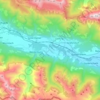
Name: Dellach topographic map, elevation, terrain.
Location: Dellach, Bezirk Hermagor, Carinthia, 9635, Austria (46.59877 13.03389 46.70196 13.11945)
Average elevation: 1,234 m
Minimum elevation: 620 m
Maximum elevation: 2,355 m
Other topographic maps
Click on a map to view its topography, its elevation and its terrain.
Lake Pressegg
Austria > Carinthia > Bezirk Hermagor > Hermagor-Pressegger See > Presseggersee > Paßriach
Average elevation: 627 m
Obermöschach
Austria > Carinthia > Bezirk Hermagor > Hermagor-Pressegger See > Hermagor
Average elevation: 765 m
Gartnerkofel
Austria > Carinthia > Bezirk Hermagor > Hermagor-Pressegger See
Average elevation: 1,705 m
Nassfeldpass / Passo di Pramollo
Austria > Carinthia > Bezirk Hermagor > Hermagor-Pressegger See > Sonnenalpe Naßfeld
Average elevation: 1,572 m