
Make a donation
Gear up for your next adventure:
As an Amazon Associate, this site earns from qualifying purchases at no extra cost to you.
Semarang topographic map
Click on the map to display elevation.
Make a donation
Gear up for your next adventure:
As an Amazon Associate, this site earns from qualifying purchases at no extra cost to you.
Semarang
Semarang is located on the northern coast of Java. The city of Semarang is one of the most important cities located on the north coast of Java and is the main hub connecting Jakarta and Surabaya, and cities in the southern interior of Java Surakarta and Yogyakarta. Semarang City has a height ranging from 2 m (6.6 ft) below sea level up to 340 m (1,120 ft) above sea level with a slope of 0%–45%. Semarang City is a city that has a unique topographic condition in the form of a narrow lowland area and hilly areas extending from the west side to the east side of Semarang City. The city is located about 558 km (347 miles) east of Jakarta and 312 km (194 miles) west of Surabaya.
Make a donation
Gear up for your next adventure:
As an Amazon Associate, this site earns from qualifying purchases at no extra cost to you.
About this map
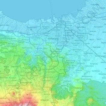
Name: Semarang topographic map, elevation, terrain.
Location: Semarang, Central Java, Java, Indonesia (-7.11446 110.26729 -6.93199 110.50888)
Average elevation: 110 m
Minimum elevation: -1 m
Maximum elevation: 822 m
Make a donation
Gear up for your next adventure:
As an Amazon Associate, this site earns from qualifying purchases at no extra cost to you.
Other topographic maps
Click on a map to view its topography, its elevation and its terrain.